Environment and natural resources
Rice Ecosystems
This vector dataset provides the locations of rice ecosystem types in Cambodia, as given by the International Rice Research Institute’s (IRRI) Cambodia-IRRI Rice Project. ...
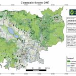
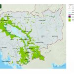
Community fisheries
Community Fisheries boundaries. ...

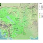
Flooded Forest
Data represents the boundary of the flooded forest within the Tonle Sap Lake. ...
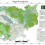
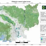
Fish Sanctuaries
Fish sanctuaries allotments. ...
Forest cover 2014
This dataset shows forest cover in Cambodia in 2014. Geographic data is encoded in the WGS 84, Zone 48 North coordinate reference system. Data were obtained in raster format from the United States Geological Survey (USGS) website and reproduced here showing forest cover by ODC. ...
Forest cover 2009
This dataset shows forest cover in Cambodia in 2009. Geographic data is encoded in the WGS 84, Zone 48 North coordinate reference system. Data were obtained in raster format from the United States Geological Survey (USGS) website and reproduced here showing forest cover by ODC. ...
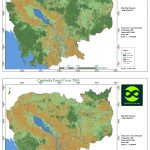
Forest cover 2004
This dataset shows forest cover in Cambodia in 2004. Geographic data is encoded in the WGS 84, Zone 48 North coordinate reference system. Data were obtained in raster format from the United States Geological Survey (USGS) website and reproduced here showing forest cover by ODC. ...
Forest cover 2000
This dataset shows forest cover in Cambodia in 2000. Geographic data is encoded in the WGS 84, Zone 48 North coordinate reference system. Data were obtained in raster format from the United States Geological Survey (USGS) website and reproduced here showing forest cover by ODC. ...
Forest cover 1989
This dataset shows forest cover in Cambodia in 1989. Geographic data is encoded in the WGS 84, Zone 48 North coordinate reference system. Data were obtained in raster format from the United States Geological Survey (USGS) website and reproduced here showing forest cover by ODC. ...
Forest cover 1973
This dataset shows forest cover in Cambodia in 1973. Geographic data is encoded in the WGS 84, Zone 48 North coordinate reference system. Data were obtained in raster format from the United States Geological Survey (USGS) website and reproduced here showing forest cover by ODC. ...

