Land

Registered indigenous communal land

This dataset contains information on the land titles of the indigenous communities registered and issued by the Ministry of Land Management Urban Planing and Construction, from 2009 to 2018. Located in Mondulkiri, Ratanakiri and Kratie, the communal land titles were delivered to Kreung, Tumpoun, Mel, ...

Families with less than 1 ha rice land

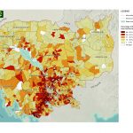
This data comes from the 2011 Commune Database produced by the NCDD (National Committee for Subnational Democratic Development). The display shows families with less than 1 hectare of rice land based upon commune level statistics.  ...
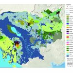
Soil types

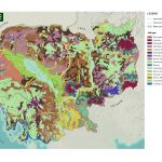
Asian Development Bank/ Environment Operations Center (www.gms-eoc.org) based on UN FAO Digital Soil Map of the World V 3.6 (www.fao.org/geonetwork).  ...

Contact us

Contact us

Do you have questions on the content published by Open Development Cambodia (ODC)? We will gladly help you.

Have you found a technical problem or issue on the Open Development Cambodia (ODC) website?

Tell us how we're doing.

Do you have resources that could help expand the Open Development Cambodia (ODC) website? We will review any map data, laws, articles, and documents that we do not yet have and see if we can implement them into our site. Please make sure the resources are in the public domain or fall under a Creative Commons license.

File was deleted
ERROR!

Disclaimer: Open Development Cambodia (ODC) will thoroughly review all submitted resources for integrity and relevancy before the resources are hosted. All hosted resources will be in the public domain, or licensed under Creative Commons. We thank you for your support.

zvGPE
* The idea box couldn't be blank! Something's gone wrong, Please Resubmit the form! Please add the code correctly​ first.

Thank you for taking the time to get in contact!