ជំនួបបច្ចេកទេសស្តីពីការធ្វើផែនទី៖ ការបង្កើនកិច្ចខិតខំប្រឹងប្រែងអភិរក្សតាមរយៈបច្ចេកវិទ្យាភូមិសាស្ត្រ
អង្គការទិន្នន័យអំពីការអភិវឌ្ឍ (អូឌីស៊ី) បានរៀបចំជំនួបបច្ចេកទេសស្តីពីការធ្វើផែនទីរយៈពេលកន្លះថ្ងៃ នៅថ្ងៃទី០៩ ខែធ្នូ ឆ្នាំ២០២៥។ ព្រឹត្តិការណ៍នេះបានប្រមូលផ្តុំអ្នកជំនាញបច្ចេកទេស អ្នកអភិរក្ស និងអ្នកពាក់ព័ន្ធក្នុងស្រុក ដើម្បីផ្លាស់ប្តូរការយល់ដឹងអំពីវិធីសាស្ត្រដែលបច្ចេកវិទ្យាភូមិសាស្ត្រអាចពង្រឹងដល់ការត្រួតពិនិត្យព្រៃឈើ និងកិច្ចការងារអភិរក្សនៅទូទាំងប្រទេសកម្ពុជា។
ដោយមានអ្នកចូលរួមចំនួន ១៧ នាក់ រួមទាំងអ្នកជំនាញ អ្នកស្រាវជ្រាវ សិស្ស-និស្សិត អង្គការសង្គមស៊ីវិល និងតំណាងវិស័យឯកជន។ ជំនួបនេះបានបម្រើជាកន្លែងសហការដើម្បីពិភាក្សាអំពីការអនុវត្តជាក់ស្តែងនៃឧបករណ៍ធ្វើផែនទី និងកសាងបណ្តាញបច្ចេកទេសឱ្យកាន់តែរឹងមាំ។
ព្រឹត្តិការណ៍នេះមានគោលបំណង៖
- ផ្លាស់ប្តូរចំណេះដឹង និងបទពិសោធន៍ជាក់ស្តែងលើឧបករណ៍ធ្វើផែនទីព្រៃឈើ
- ពង្រឹងបណ្តាញបច្ចេកទេសក្នុងចំណោមអ្នកពាក់ព័ន្ធក្នុងស្រុក
- លើកកម្ពស់កិច្ចខិតខំប្រឹងប្រែងសហការក្នុងការត្រួតពិនិត្យ និងការអភិរក្សព្រៃឈើ
បទបង្ហាញទី ១៖ ការត្រួតពិនិត្យព្រៃឈើនៅក្នុងទេសភាពភ្នំក្រវាញកណ្តាល
កញ្ញា គង់ បូរី អ្នកសម្របសម្រួល GIS អង្គការអភិរក្សអន្តរជាតិកម្ពុជា (CI) បានចែករំលែកវិធីសាស្ត្រជាក់ស្តែងរបស់អង្គការ CI ក្នុងការត្រួតពិនិត្យការផ្លាស់ប្តូរគម្របព្រៃឈើនៅក្នុងតំបន់ដែលមានជីវចម្រុះបំផុតមួយរបស់ប្រទេសកម្ពុជា។ អង្គការ CI អនុវត្តដំណើរការការងារប្រាំជំហានដែលមានរចនាសម្ព័ន្ធ ដើម្បីធានាបាននូវការរកឃើញ Detection និងការផ្ទៀងផ្ទាត់ការកាប់បំផ្លាញព្រៃឈើដែលអាចទុកចិត្តបាន៖
- ការប្រើប្រាស់រូបភាពផ្កាយរណប
- វិភាគ និងធ្វើឌីជីថលនៅកន្លែងដែលការកាប់បំផ្លាញព្រៃឈើ
- ចែករំលែកព័ត៌មានអំពីការកាប់បំផ្លាញព្រៃឈើជាមួយអ្នកយាមសម្រាប់ការល្បាត
- ការផ្ទៀងផ្ទាត់សំណាក
- របាយការណ៍
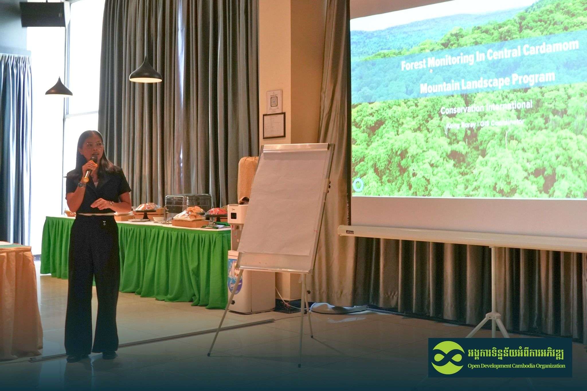
អង្គការ CI ប្រើប្រាស់រូបភាព Sentinel-2 ជាចម្បង និងទិន្នន័យ PlanetScope ពីមុន។ នៅពេលដែលការគ្របដណ្តប់របស់ Sentinel-2 មានកម្រិត ជាពិសេសក្នុងអំឡុងពេលមានពពកច្រើន អង្គការ CI អាចពិនិត្យឡើងវិញជាមួយនឹងការជូនដំណឹងរបស់ Global Forest Watch (GFW)។
បទបង្ហាញបានបញ្ជាក់ពីប្រសិទ្ធភាពនៃការធ្វើឌីជីថលដោយដៃ ដែលជារឿយៗបង្កើតលទ្ធផលល្អ និងត្រឹមត្រូវជាងបើប្រៀបធៀបទៅនឹងប្រព័ន្ធចាត់ថ្នាក់ដោយស្វ័យប្រវត្តិ។ នេះមានសារៈសំខាន់ជាពិសេសក្នុងអំឡុងពេលរដូវវស្សា នៅពេលដែលពពក និងរុក្ខជាតិដុះឡើងវិញអាចបំភាន់វិធីសាស្ត្រដោះស្រាយដោយស្វ័យប្រវត្តិ។
បទបង្ហាញទី ២: ការប្រើប្រាស់ SMART និង EarthRanger សម្រាប់ការងារអភិរក្សប្រកបដោយប្រសិទ្ធភាព
លោក សុខ លីអាន អ្នកជំនាញខាងបច្ចេកវិទ្យាអភិរក្ស ការធ្វើផែនទី GIS និងការគ្រប់គ្រងតំបន់ដីសើម អង្គការសមាគមអភិរក្សសត្វព្រៃ (WCS) បានបង្ហាញបទពិសោធន៍របស់អង្គការ WCS ដោយប្រើប្រាស់ឧបករណ៍ឌីជីថល ដើម្បីការពារវាលទំនាបលិចទឹកទន្លេសាបដ៏សំខាន់ខាងអេកូឡូស៊ី ដែលជាតំបន់មួយដែលប្រឈមមុខនឹងការគំរាមកំហែងកាន់តែខ្លាំងឡើងពី៖
- ការជួញដូរសត្វព្រៃ
- ប្រភេទសត្វឈ្លានពាន
- ការបាត់បង់ជម្រក
- ការចូលរួមសហគមន៍មានកម្រិត ដោយសារតែចំណេះដឹងឌីជីថលទាប
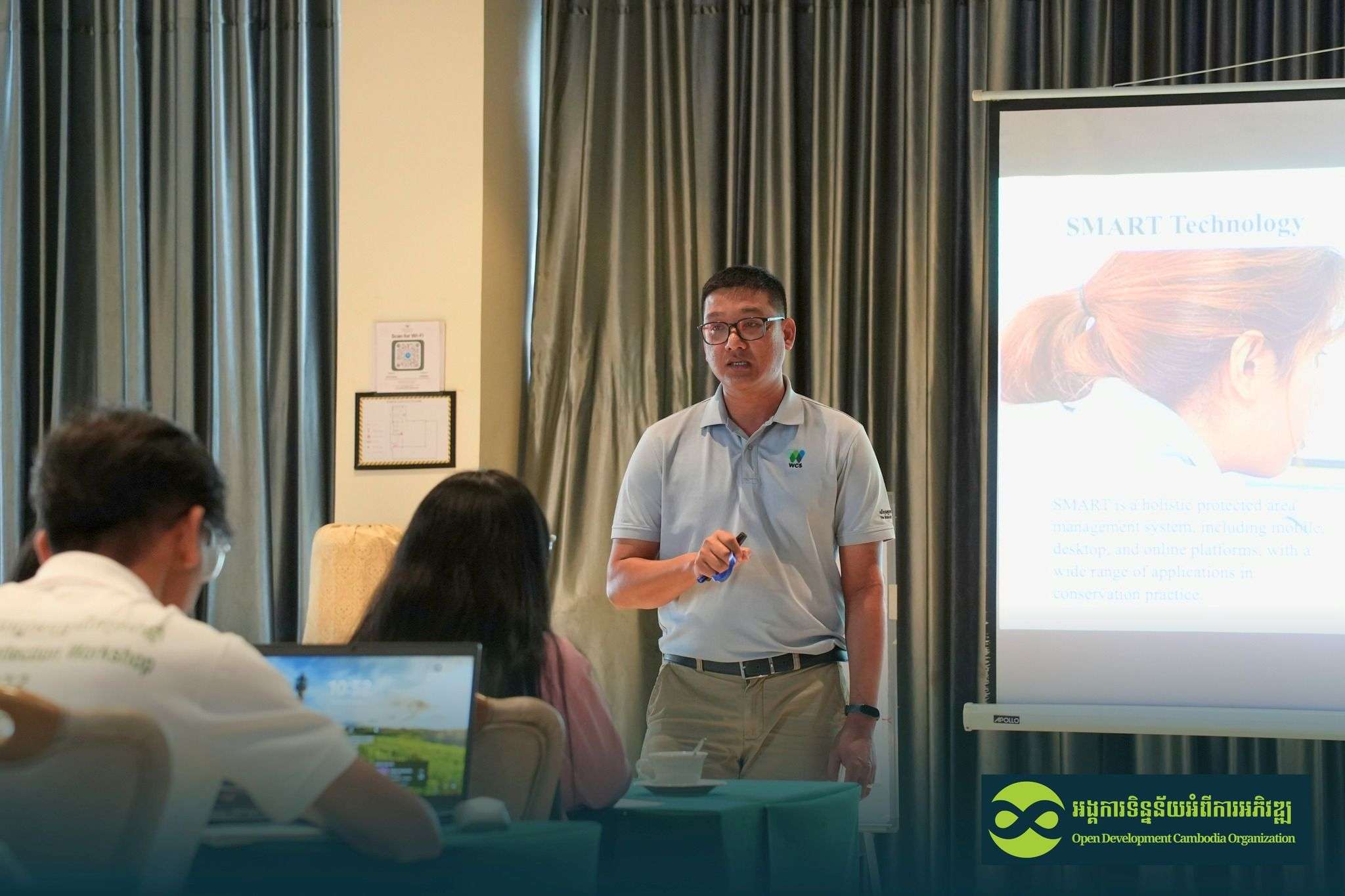
អង្គការ WCS ពឹងផ្អែកលើប្រព័ន្ធ SMART (ឧបករណ៍ត្រួតពិនិត្យ និងរាយការណ៍ក្នុងលំហ) ដើម្បីគាំទ្រដល់អ្នកល្បាត និងក្រុមល្បាតសហគមន៍។ កម្មវិធី SMART ផ្តល់ជូន
- ផ្ទៃរូបភាពជាភាសាខ្មែរ ដែលសមស្របសម្រាប់អ្នកប្រើប្រាស់ដែលមានចំណេះដឹងទាប
- ការបញ្ចូលទិន្នន័យផ្អែកលើសំឡេង និងរូបតំណាងដែលមានភាពងាយស្រួល
- ឧបករណ៍សម្រាប់បង្កើតផែនការល្បាត ផែនទីចំណុចសំគាល់ (Hotspot map) និងរបាយការណ៍ឧប្បត្តិហេតុ
- មូលដ្ឋានទិន្នន័យដែលមានកំណត់ត្រាចាប់ពីឆ្នាំ២០១៥ ដល់បច្ចុប្បន្ន
ការតភ្ជាប់អ៊ីនធឺណិតមានកម្រិតនៅតែជាបញ្ហាប្រឈមសម្រាប់ការជូនដំណឹងតាមពេលវេលាជាក់ស្តែង។ ដើម្បីដោះស្រាយបញ្ហានេះ អង្គការ WCS បានចាប់ផ្តើមសាកល្បងការទំនាក់ទំនងផ្កាយរណប Garmin inReach នៅក្នុងទិដ្ឋភាពមួយចំនួន ដើម្បីបង្កើនសមត្ថភាពឆ្លើយតបរហ័ស។
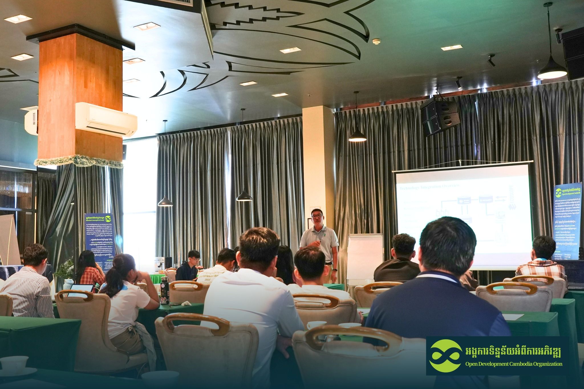
អង្គការ WCS បំពេញបន្ថែម SMART ជាមួយនឹងឧបករណ៍ទំនើបៗដូចជា៖
- EarthRanger ដែលរួមបញ្ចូលទិន្នន័យ SMART ជាមួយប្រភពខាងក្រៅដូចជាការជូនដំណឹងអំពីការបាត់បង់ដើមឈើ GFW និងទិន្នន័យភ្លើងឆេះរបស់ NASA FIRMS
- Ecoscope ដែលជាវេទិកាមួយដែលបញ្ចូលព័ត៌មានច្រើនប្រភពទៅក្នុងផ្ទាំងគ្រប់គ្រងដែលងាយស្រួលសម្រាប់ការវាយតម្លៃ និងការធ្វើការសម្រេចចិត្ត
ការរួមបញ្ចូលទាំងនេះអនុញ្ញាតឱ្យអង្គការ WCS មើលឃើញលំនាំ កំណត់អត្តសញ្ញាណការគំរាមកំហែង និងសម្របសម្រួលយុទ្ធសាស្ត្រអភិរក្សដែលមានប្រសិទ្ធភាពជាងមុន។
ពង្រឹងកិច្ចសហការសម្រាប់ការការពារព្រៃឈើ
បទបង្ហាញបានគូសបញ្ជាក់ពីសារៈសំខាន់កាន់តែខ្លាំងឡើងនៃបច្ចេកវិទ្យាភូមិសាស្ត្រក្នុងការដោះស្រាយការកាប់បំផ្លាញព្រៃឈើ និងការបាត់បង់ជីវចម្រុះនៅក្នុងប្រទេសកម្ពុជា។ ចាប់ពីការវិភាគរូបភាពផ្កាយរណបរហូតដល់ការប្រមូលទិន្នន័យចល័ត និងប្រព័ន្ធជូនដំណឹងរួមបញ្ចូលគ្នា បច្ចេកវិទ្យាកំពុងផ្តល់ឱ្យក្រុមអភិរក្សនូវឧបករណ៍ចាំបាច់ដើម្បីធ្វើការសម្រេចចិត្តលឿនជាងមុន និងមានព័ត៌មានកាន់តែច្រើន។
ជំនួបបច្ចេកទេសស្តីពីការធ្វើផែនទីបានបង្ហាញពីតម្លៃនៃការនាំយកអ្នកជំនាញមកជួបជុំគ្នាដើម្បីចែករំលែកបទពិសោធន៍ក្នុងពិភពពិត ដោះស្រាយបញ្ហាប្រឈម និងកំណត់ឱកាសសម្រាប់កិច្ចសហការ។

