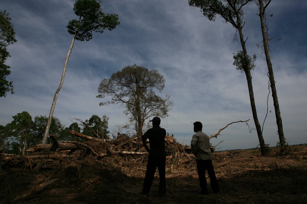
សឿន រ៉ន (ឆ្វេង) និងអ្នកក្នុងភូមិជាមួយលោក នៅដីឈូសឆាយមួយកន្លែង ដែលដើមឈើជ័រទឹកធ្លាប់តាំងនៅ ក្នុងភូមិអូរព្រះ ខេត្តក្រចេះ។ រូបភាព ថតដោយអង្គការ Oxfam GB ប្រចាំអាស៊ី កាលពីថ្ងៃទី១ ខែមករា ឆ្នាំ២០០០។ ក្រោមអាជ្ញាប័ណ្ណ CC BY-NC-ND 2.0
គម្របព្រៃឈើ នៃប្រទេសកម្ពុជា បានថយចុះយ៉ាងគំហុកនៅក្នុងប៉ុន្មានទសវត្សរ៍ចុងក្រោយនេះ។ នៅឆ្នាំ១៩៧៣ ប្រទេសកម្ពុជា មានផ្ទៃដីព្រៃសរុបចំនួន ១៣.១លានហិកតា ប៉ុន្តែ គិតត្រឹមឆ្នាំ២០១៤ គម្របព្រៃរបស់ប្រទេសនេះ បានធ្លាក់ចុះមកនៅត្រឹម ៨.៧ លានហិកតា។ ជាលើកទី១ នៅក្នុងអំឡុងពេល ៤១ឆ្នាំ ដែល ភាគរយនៃគម្របដីមិនមែនព្រៃ (៤៨.៤%) មានទំហំធំជាងភាគរយនៃគម្របព្រៃឈើ (៤៧.៧%)។1
ការបាត់បង់ភាគច្រើន គឺមានទៅលើព្រៃស្រោង−ព្រៃចំណាស់ សឹងតែបៃតងជានិច្ច និងភាគច្រើនមិនទាន់ការ រំខានយាយី−ដែលបានធ្លាក់ចុះជាងពាក់កណ្តាល ពីចំនួន ៧.៦ លានហិតា មកនៅត្រឹមតែ ៣ លានហិកតា។ នេះ គឺជាការបាត់បង់តំបន់ព្រៃស្រោង ដែលមានទំហំធំជាងប្រទេសមួយទាំងមូល ដូចជាប្រទេសដាណឺម៉ាក។
ផែនទីរបស់អង្គការទិន្នន័យអំពីការអភិវឌ្ឍ បង្ហាញពីនិន្នការនៃការបាត់បង់ព្រៃស្រោង នៅក្នុងរយៈពេល ៤១ ឆ្នាំចុងក្រោយ នៅប្រទេសកម្ពុជា ដែលស៊ីគ្នាទៅនឹងការរកឃើញរបស់ក្រុមអ្នកជំនាញដទៃទៀត ដូចជា សាកលវិទ្យាល័យម៉ារីលែន (ហេនសាន់ និងសហសេវិក)2 និង មូលនិធិសកលលោកសម្រាប់អភិរក្ស ធម្មជាតិ (WWF)។3 ផែនទី ដែលផ្អែកលើការសិក្សារបស់សាកលវិទ្យាល័យម៉ារីលែន អាចរកបាននៅលើ គេហទំព័រ របស់អង្គការឃ្លាំមើលព្រៃឈើសកលលោក។4
បន្ថយល្បឿនការបាត់បង់ព្រៃឈើ
អង្គការ និងបុគ្គលជាច្រើន បានសម្តែងការព្រួយបារម្ភពីការបាត់បង់គម្របព្រៃឈើនៅប្រទេសកម្ពុជា យ៉ាងគំហុក ។ ឧទាហរណ៍ គោលដៅអភិវឌ្ឍន៍សហស្សវត្សរ៍ នៃប្រទេសកម្ពុជា មានរាប់បញ្ចូលទាំងការ រក្សាគម្របព្រៃឈើយ៉ាងហោចណាស់ ឱ្យបាន ៦០% នៅត្រឹមឆ្នាំ២០១៥5 (ជាផ្នែកមួយនៃគោលដៅទី៧)។ ការប្តេជ្ញានេះ មិនត្រូវសម្រេចបានទេ។ ដូចដែលបានរៀបរាប់មកពីខាងដើម គម្របព្រៃឈើនៅពេលបច្ចុប្បន្ន គឺមានអត្រាភាគរយទាបជាងរួចទៅហើយ នៅប្រមាណជា ៤៨%។
របៀបគណនាគម្របព្រៃឈើ
រូបភាពផ្កាយរណប នៃប្រទេសកម្ពុជា ដែលមានអាយុកាល ត្រឡប់ទៅ ទសវត្សរ៍ ឆ្នាំ១៩៧០ អាចរកបានជាសាធារណៈ។ រូបភាព ដែលយកមកប្រើដើម្បីគណនាគម្របព្រៃឈើ ត្រូវបានជ្រើសរើសដោយផ្អែកលើគុណភាពខ្ពស់របស់រូប និងដោយមិនមានគម្របពពក។ ដោយសារតែ យើងមានទាំងរដូវវស្សា និងរដូវប្រាំង ហើយដីមានរូបភាពកាន់តែខៀវបំព្រង នៅរដូវវស្សា ដូច្នេះ រូបភាពដែលត្រូវបានផលិតឡើងនៅក្នុងឆ្នាំនោះ ក៏ត្រូវតែពិចារណាអំពីភាពមិនផ្លាស់ប្តូររបស់វាផងដែរ។
រូបភាពដើមរបស់ផ្កាយរណប មានពណ៌ប៊ែនផ្សេងគ្នាជាច្រើន។ ការញែកពណ៌ទាំងនេះ អនុញ្ញាតឱ្យ អូឌីស៊ី ធ្វើចំណាត់ថ្នាក់ទៅលើប្រភេទគម្របដី ដែលបង្ហាញជាព្រៃស្រោង ព្រៃល្បោះ ដីមិនមែនព្រៃ ទឹក ឬ ពពក។ ឧទាហរណ៍ រូបភាពដែលមានកម្រិតភាពច្បាស់ខ្ពស់ អាចរកបាននៅប៉ុន្មានឆ្នាំថ្មីៗនេះ មានន័យថា រង្វាស់របស់ព្រៃស្រោង អាចធ្វើបានកាន់តែច្បាស់នាពេលសព្វថ្ងៃ។
ផែនទីរបស់អូឌីស៊ី គឺជាផែនទី អំពីគម្របព្រៃឈើតែមួយគត់សម្រាប់ប្រទេសកម្ពុជា ដែលលាតសន្ធឹងលើរយៈ ពេល ៤០ឆ្នាំ។ នៅឆ្នាំ២០០៦ នាយកដ្ឋានរដ្ឋបាលព្រៃឈើ នៃប្រទេសកម្ពុជា បានបោះពុម្ពផ្សាយផែនទីមួយ ដែលបង្ហាញអំពី គម្របព្រៃឈើក្នុងឆ្នាំ២០០២។ បន្ទាប់មក នៅឆ្នាំ២០១១ រដ្ឋបាលព្រៃឈើ ដោយមានការគាំទ្រពីអង្គការអន្តរជាតិឈើតំបន់ត្រូពិច និងរដ្ឋាភិបាលនៃប្រទេសដាណឺម៉ាក បានបោះពុម្ពផ្សាយគម្រប ព្រៃឈើ ឆ្នាំ២០១០ ដែលមានផែនទីបង្ហាញពីការប្រែប្រួលគម្របព្រៃឈើ សម្រាប់ឆ្នាំ២០០៦-២០១០ និង ឆ្នាំ២០០២-២០១០។6 ដោយហេតុថា ប្រទេសកម្ពុជាមិនទាន់មានផែនទីផ្លូវការ ឬការវិភាគជាក់លាក់ណាត្រូវបានបោះពុម្ពផ្សាយចាប់តាំងពីពេលនោះមក អង្គការទិន្នន័យអំពីការអភិវឌ្ឍ បានសម្រេចធ្វើការផលិតសំណុំផែនទីគម្របព្រៃឈើបច្ចុប្បន្នភាពនេះឡើង។
បច្ចុប្បន្នភាព៖ ២២ កញ្ញា ២០១៥
ទាក់ទងនឹងគម្របព្រៃឈើ
ឯកសារយោង
- 1. អង្គការទិន្នន័យអំពីការអភិវឌ្ឍ. ឆ្នាំ២០១៥. “ការសិក្សាអំពីគម្របព្រៃឈើ (១៩៧៣-២០១៤).” https://opendevelopmentcambodia.net/km/profiles/forest-cover/
- 2. Hansen, M.C., P.V. Potapov, R. Moore, M. Hancher, S.A. Turubanova, A. Tyukavina, D. Thau, S.V. Stehman, S.J. Goetz, T.R. Loveland, A. Kommareddy, A. Egorov, L. Chini, C.O. Justice, and J.R.G. Townshend. “ផែនទីសកលស្តីពីការប្រែប្រួលគម្របព្រៃឈើសតវត្សរ៍ទី២១ ក្នុងកម្រិតភាពច្បាស់ខ្ពស់” វិទ្យាសាស្ត្រ លេខ៣៤២ (ថ្ងៃទី១៥ ខែវិច្ឆិកា ឆ្នាំ២០១៣):៨៥០-៨៥៣. [DOI:10.1126/science.1244693].
- 3. មូលនិធិសកលលោកសម្រាប់អភិរក្សធម្មជាតិ. “របាយការណ៍អំពីព្រៃឈើមានជីវិត.” ចូលអាន ថ្ងៃទី១៣ ខែកក្កដា ឆ្នាំ២០១៥. http://wwf.panda.org/about_our_earth/deforestation/forest_publications_news_and_reports/living_forests_report/ ។
- 4. អង្គការឃ្លាំមើលព្រៃឈើសកលលោក. “អំពីអង្គការឃ្លាំមើលព្រៃឈើសកលលោក.” ចូលអាន ថ្ងៃទី១៣ ខែកក្កដា ឆ្នាំ២០១៥. http://www.globalforestwatch.org/ ។
- 5. អង្គការស្បៀងនិងកសិកម្មនៃអង្គការសហប្រជាជាតិ . ឆ្នាំ២០១០. ការសិក្សាស្តីពីចក្ខុវិស័យព្រៃឈើនៃប្រទេសកម្ពុជា ។
- 6. រដ្ឋបាលព្រៃឈើ. ក្រសួងកសិកម្ម រុក្ខាប្រមាញ់ និងនេសាទ. (២០១១). គម្របព្រៃឈើនៃប្រទេសកម្ពុជា ឆ្នាំ២០១០. ចូលអាន ថ្ងៃទី៣១ ខែមីនា ឆ្នាំ២០១៥. http://www.twgfr.org/itto/wp-content/uploads/2012/06/Cambodia-Forest-Cover-2010_KH.pdf ។

